Showing posts with label White Cliffs of Dover. Show all posts

Friday, 30 March 2012

Moving along (the cliff)

Further around the coast and just beyond Dover, you come to Langdon Cliffs owned by the National Trust.  I have always resolutely turned my back on this because it seemed somehow very wrong to have to pay to walk along the coast.  I take it all back now.

I did have to pay to park the car but had I been on foot there would have been no charge.  Of course there is nowhere remotely close by for parking at the Dover end of the cliffs.  Maybe there is further along but that I don't know.  A nominal fee of £3 isn't exorbitant in any case so I was perfectly happy, the facilities provided are good (lovely cakes!), and the cliffs are well maintained.

The car park, part of it anyway, over looks the cross channel Eastern docks at Dover.  There is something mesmerising about watching the ferries arrive, manoeuvre into position, disgorge passengers and freight, re-load and depart, only to have the berths re-occupied within a very short time.


But I was here to see the cliffs so off I trotted.  Not too fast because the paths, which were on at least three levels, were really quite rough and really quite close to the edge....


There were warning signs up about the recent landslip but that seemed rather like shutting the door after the horse had bolted.  The result of the slide was easily visible from quite a distance.


Neither that nor the signs stopped people from looking closely.


I didn't notice anyone until I was going through these photos at home, and I've had to zoom as much as possible.  If you click on the picture you should be able to make out a few foolhardy souls who had gone for a closer inspection of the landslip and appeared to be standing right on the edge.

The area is a Site of Special Scientific Interest because of the varieties of flora and fauna to be found on the chalk grassland.  To maintain the grassland, the National Trust has brought in a number of Exmoor ponies to graze the land and keep over-vigorous grasses under control.  The ponies looked at me with some suspicion but didn't run away.


I imagine they would soon move if anyone approached too closely but I don't know how tame they are.  There are notices asking people not to feed the ponies.

The views are superb:


over the cliff tops


towards Dover Castle


and to the rocks below.

On a clear day, of course not this day, you should be able to see France.

The protected area continues over the cliffs to South Foreland Lighthouse and St Margaret's Bay, a route I'm saving for another day.

Thursday, 18 November 2010

Samphire Hoe

Samphire: corruption of the French Saint Pierre.  an edible plant sometimes called sea asparagus.  It doesn't taste in the least like asparagus but it's delicious.  In France it's salicorne, or Salicornia, though in the UK it's a different species entirely, rock samphire,  growing on cliffs and mentioned by Shakespeare in King Lear: "Half-way down, Hangs one that gathers samphire; dreadful trade!".

Hoe: a piece of land that juts out into the sea.

Samphire Hoe:  a piece of land reclaimed from the sea using the spoil from the excavation of the Channel Tunnel and officially opened to the public in 1997.  It is the newest part of Kent, between the famed White Cliffs and the English Channel just to the west of Dover.


This wonderful location provides peace and quiet, walking and wildlife.  This view is to the east, towards Dover.


In this view to the west you can see the main line railway to Dover as it follows the base of the cliffs, disappearing into it from time to time.  It's actually quite a spectacular train journey at times, right on the edge of the sea.


In order to reach Samphire Hoe, you have to go through this tunnel.  To the left you can just sea the rail tunnels.  To the right are the works for Eurotunnel.


The west beach, a shingle or pebbled beach, gives a view of Folkestone.  Unlike Deal beach, it's quite rocky at low tide and would merit further investigation.


A good view of the sea wall construction.  It consists of two rows of sheet piles driven into the sea bed, the space between the two walls being filled with concrete.  On the outer edge boulders are piled up to stop the sea from undermining the base of the wall.


Material was placed behind the walls and topped with concrete slabs to create terracing.  This allows the water to run off and out through the drainage gaps on the lip of the sea wall.  The round concrete blocks on the wall provide access to the site drains.

I fondly imagined the terracing was intended to view spectacles out at sea or in Folkestone, firework displays or something similar, until I read one of the several information placards which told me the more mundane truth.


 This one described some of the birds I didn't see.  There were plenty of gulls though.


Somewhere halfway up this cliff is where the samphire grows, they say.  I didn't try to find out.  The little hut or shelter at the top is, I think, a view point from the North Downs Way which runs along the top of the cliff.  I'll save that one for another day.


This was the view from the road on the way home.  The cliff straight ahead is Shakespeare Cliff with Samphire Hoe below and to the west.  Dover harbour is straight ahead with one of the cross channel ferries about to leave.

Who would believe, on a day like this, that just a few days earlier the wind was so strong that they considered closing the harbour for a time.
Enhanced by Zemanta

Tuesday, 17 August 2010

From the White Cliffs


The White Cliffs seen from the lookout at Dover Castle, but this isn't about the White Cliffs themselves, just the view from them.


If you were to follow the cliffs around, you would end up in St Margaret's Bay. There is a hair-raising road down to the bay, or a hair-raising pathway. Take your pick.


The main ferry terminal for cross-channel routes. It didn't look terribly busy that day, but of course it was mid-week and the summer season will soon be drawing to a close.  On occasions, mainly if something is going wrong, you can get queues of cars and lorries just waiting to get into the docks area, either all the way down that sloping road, or right through Dover itself.  Best not to venture out on those days.


Although it looked busy enough, some of the ferry operators are struggling. From Dover you can cross to Dunkirk (Dunkerque), Boulogne or Calais.


Looking over Dover and the western docks from the top of the castle keep. There is now a terminal for cruise ships, as well as marinas. Much of Dover had to be rebuilt after WWII.


Another view from the castle keep, this time showing the Western Heights, considered to be some of the most impressive fortifications in Great Britain.  It is asking for a visit of its own. Any day now.
Enhanced by Zemanta

Thursday, 20 May 2010

Around the Kent coast

This post has been written for Blogtrotting.  Go along and visit to take a tour around the world!


I've lived in the south east of England for less than a year (and chose the worst winter in living memory to arrive) so I'm still in a learning phase.  From a point of view of history, it's a fascinating area because so many invasions of the island came through here or someone had hoped that they would.  Everywhere you turn you can see signs of the efforts to fight off these invasions.

I thought I'd take you on a brief and rapid tour of the coastline I've so far explored, starting at Hythe, just to the west of Folkestone.  Hythe is one of the places, there are several around here, which used to be on the sea but the centre is now well inland.  The name Hythe means haven or landing place so the sea must have been there once.  It was one of the Cinque Ports set up in 1155, coastal towns that maintained ships ready for use by the Crown.  Walking through the town, one of the first things you notice is the Military Canal.  Now it's a pleasant and attractive area for relaxing, but it was built 1804-1809 to defend against possible invasion during the Napoleonic Wars.  It's 28 miles long and had a Royal Military Road built alongside it now giving people the opportunity to walk or ride its length.


Moving along the coast to Folkestone now.  Although it suffered invasions in its time, it's witness to the opposite too, an exodus of holiday makers from the UK to France - first from being a ferry port, then a hovercraft port, and now it hosts one end of the channel tunnel.

Folkestone beach and remains of hoverport

Cars loading on to Channel Tunnel train

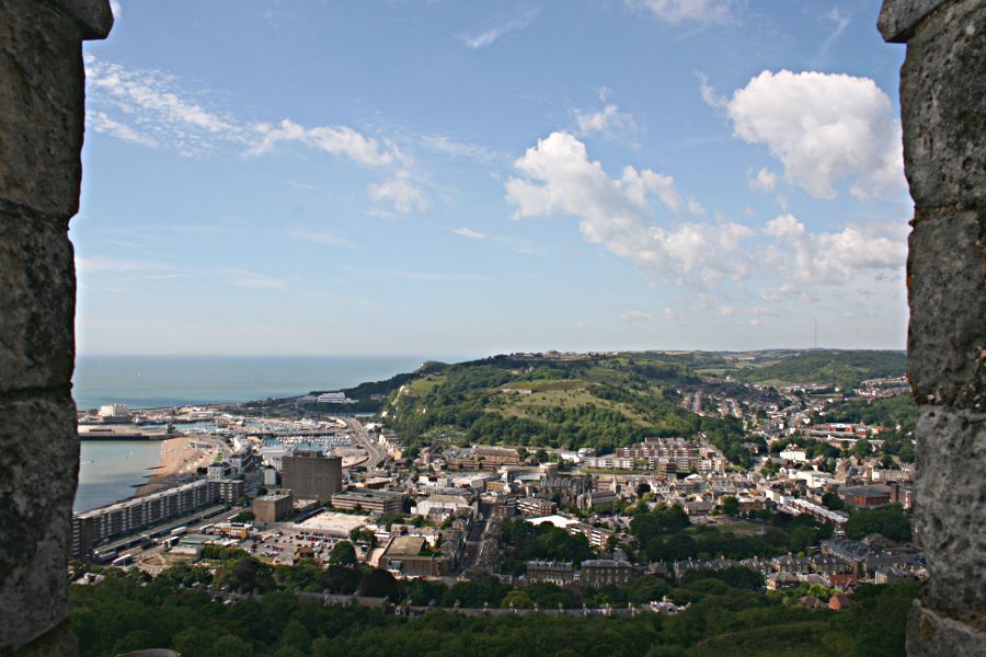
Folkestone has cliffs but nothing like the white cliffs of Dover, our next stop along the way. Once my parents lived on top of those cliffs so I know the fantastic views from walks along the cliff tops. The cliffs are about to undergo "refurbishment" by which they mean the removal of some of the scrub that's grown on the cliff face and spoils the "whiteness".

Dover Castle above the white cliffs


Dover is so much more than white cliffs though, with its castle high up on the cliff guarding the area from invasion ever since the 12th century right up until World War II.

Dover Castle seen from the land side

Now it's one of the main crossing points to Europe.

The Port of Dover from the castle

Cross Channel ferries continually going to and fro


You'll notice the beach at Dover - shingle, or pebbled, like so many others in this part of the world.  Shingle beaches are fairly unusual elsewhere and provide a particular habitat for wildlife, protected in some places.

Further along, and passing the place where the Romans first set foot in Britain, the small town of Deal used to be the busiest port in England, though now it's hard to imagine.  The Goodwin Sands sheltered (still do) ships' moorings and until  steam powered ships were commonplace the town (and smuggling) flourished.

Deal sea front

Middle Street, a hotbed of smuggling


Deal Castle, built by Henry VIII, is the most obvious reminder of days gone by.


The next place I'd like to show you is Sandwich, another town that was once a port and is now quite a distance from the sea.

Sandwich quay


In 1023 King Canute granted a charter to the monks of Christchurch Canterbury to operate a ferry across the river and collect fares.  The Barbican was built in 1740 and beneath it is a list of the old tolls due.

The Barbican, Sandwich, with The Crispin inn next door


There are various ancient inns nearby.  The one next to the Barbican, the Crispin, dates from 1491 but as an inn only since 1769.  Before that it was the home of the ferryman. It was named after the patron saint of shoemakers, said to have been shipwrecked nearby.

For those interested in golf, the Royal St George's golf course is in Sandwich and will host the 2011 Open Championship.


Ramsgate next, and here we have the only Harbour allowed call itself "Royal" in the country.


Until 1723 Ramsgate was just a fishing village but it became another of the Cinque Ports and during the Napoleonic Wars it was almost a garrison town.  It played a large part in the evacuation of Dunkirk 70 years ago, by the fleet of Little Ships.  Next week as many of the Little Ships that are able will mark the anniversary with a flotilla going across the Channel to Dunkirk once again.

Finally, breathe a sigh of relief, Whitstable, famous for its oysters since Roman times.  A lovely little seaside town with fish, shellfish and seafood available at every turn.

A well known and popular fish restaurant, with prices to match


Part of the fish market

It's so well known as a seafood town that the old railway (the Canterbury and Whitstable Line) used to be nicknamed the Crab and Winkle Line.

Of course the best known place in this part of Kent is Canterbury but anyone making a pilgrimage there for the Cathedral and old city could do far worse than to extend the journey for a quick look around the coastline, to the many other places of interest.
Reblog this post [with Zemanta]

LinkWithin

Blog Widget by LinkWithin